The Setting
This history takes place on the West Island. It was called this, with a certain lack of originality, because it occupied the west of the island of Montreal (and as one by one we moved away from it, we called it 'the Waste Island'). At this time the West Island contained a mainly English population. Though not Westmount (a suburb of Montreal (1) on the west face of Mount Royal, where the large mansions were kept), the area was certainly not poor...just middle class suburbia.
At one time most of this area had been farmland, of which sections of Kirkland, Ste-Anne de Bellevue, Senneville and Pierrefonds still were. A building boom was on though, in Dollard des Ormeaux, Kirkland, Pierrefonds and other municipalities (Dollard was the worst offender, throwing up rows of uninteresting houses, leaving not a tree in sight (well, almost)).
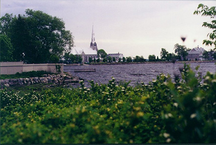 I lived in Pointe Claire (2). Named for a point of land that jutted out into the lake, it was the site of an old windmill (the city's logo). From there early settlers had made a lookout for Indian attacks from across the river. A large Catholic cathedral and convent were later built nearby.
Pointe Claire’s most fashionable area was that along Lac St. Louis (with a beautiful view but the lake had an evil reputation, being very polluted). Lakeshore Road ran along the lake’s shore, and here were the biggest and most expensive homes (some of which began life as summer homes for rich Anglos in the late 19th and early 20th century, when Pointe Claire had been an escape into the country)
Through southern Pointe Claire, going east/west, ran the old main highway, called the 2&20. It started off the island to the west and went into the city of Montreal. Running parallel to it (to the north) were the train tracks, one set for the CP (Canadian Pacific) railway line and one for the CN (Canadian National).
Pointe Claire had two main divisions: above the tracks and below. Above the tracks, which was most of the city, were homes mainly built in the 1950’s and ‘60’s. It had three high schools, St. Thomas (Catholic, see October 1, 1971), Lindsey Place (Protestant) and John Rennie (also Protestant, and the focus of a large part of this story), a library, a combined fire/police station-city hall, a large hospital, and an arena (completed in 1967, it had been a centennial project to celebrate the 100th birthday of Canada, called the Civic Centre) with a skating rink and Olympic size pool.
The city’s main north-south street was St. John’s, which also ran north up through Dollard and Pierrefonds. Through the north (running east/west) ran the TransCanada Highway, location of the shopping mall Fairview (where the highway and St John’s met, see July 3, 1970), and the industrial park. The next street south, running parallel to it was Hymus, again industrial (in a suburban sort of way). The tavern the Manior (see February 24, 1972) was at the corner of Hymus and St. John's Road.
 Below the tracks (where I lived), were areas representing different eras. My area was mainly built during the 1940’s and ‘50’s (our house and the other four at our end of the street were all built during 1965, and were the last to be built on Winston Circle). Trees, trees and more trees. Mainly maples, cedars and elms (at least until the late 1970’s, when Dutch Elm disease destroyed many trees). Sidewalks were rare (Cedar Ave had one for example. This street ran north/south just east of my street. At the top were the tunnels, which ran under the highway 2+20, leading to Cedar Park train station), and there were petitions to prevent others from being built (“to preserve the character of the neighbourhood”). East on the other side of St. John’s was Priest’s Farm (built on land once owned by the Catholic church), homes built in the late ‘50’s and early ‘60’s. The main road connecting these two areas ran east-west and was called Lakeview. It had a sidewalk.
At the south-west corner of Pointe Claire was the village, which every since childhood we had known was different because there were actual French people living there (imagine that?). There were shops, a tavern and one or two buildings dating back to the 18th century.
To the east where Lakeshore Road began to arc to run along the edge of Valois bay and meet Lakeview was the Maples Inn (see below September 18, 1971). A few streets east of that was Ovide Park, and not much further east was Sunnyview, Lesley Astle’s street [see September 25, 1971].
We moved into a house that my father designed at 72 Winston Circle, Pointe Claire on August 29, 1965.
1 From Wikipedia 2009
The area known today as Montreal had been inhabited for some 8,000 years, while the oldest known artifact found in Montreal proper is about 4,000 years old
2 From the Pointe-Claire website (2004):
The development of the territory of "la Pointe Claire" did not truly begin until 1698-1699. After 1706, deforestation along the riverbank was advanced enough that the opening of a road along the lake, from La Présentation to the tip of the island, was decreed. In addition to the concessions bordering the lake and served by "the King's Road" (chemin du Roy, now Lakeshore Road), the parish was subdivided in three côtes : St. Rémy (Boulevard-des-Sources), St. Jean and St. Charles (currently boulevards of the same names). The parish was first established in the name of St. Francis of Sales in 1713 and dedicated to St. Joachim the following year. Between côtes St. Rémy and St. Charles lay 33 lots (no.'s 145 to 177). These were generally three acres wide by 20 or 30 acres deep.
In 1834, Monseigneur Signay decreed the canonical establishment of the parish. In 1845, Pointe-Claire became a civil entity; then, in 1854, a municipality. Agriculture was always the center of activity and the area changed little in appearance. Transformations gradually came about with the influx of English-speaking summer vacationers attracted by the area's natural features. This new social context and its activities marked the landscape and influenced the area's development until the Second World War. Real changes appeared with the coming of the Grand Trunk Railroad in 1855, which reduced the journey to Montreal to 45 minutes, as well as with the opening of the Canadian Pacific Line in 1887 and the initiation of telephone service in the 1890s. At the turn of the century, several hotels, which no longer exist, were built for vacationers, and a large number of private dwellings were rented. Seasonal cottages were also built which eventually became permanent residences.
In 1889, the area of the municipality was enlarged through the annexation of properties. On May 22, 1900, the heart of the village suffered a major fire that destroyed 23 houses along Church Street (St. Joachim Street), St. Anne Street and the current Lakeshore Road. The town was incorporated in 1911 and included the whole village, plus a fairly large section of the old parish, of which an additional part was annexed in 1958. With the construction of a highway alongside the railway in 1940, Pointe-Claire's role as a suburb was confirmed. The important part of its architectural and historical heritage is located to the south. An inventory taken in 1989 at the request of the urban planning division counted approximately 150 old buildings of interest.